

 1 / 8
1 / 8Colonial roads and modern India’s network: Roads laid down under British rule were deliberate in design, often straight and strategic to support army movement and resource extraction, but many now underpin India’s vast national and state highway systems. These colonial routes, repurposed and modernised, remain integral to daily travel and commerce across the country. (Picture: Wikimedia Commons)
 2 / 8
2 / 8Grand Trunk Road – India’s colonial transport spine: The Grand Trunk Road (GT Road) was expanded and reinforced by the British to connect Calcutta (now Kolkata) with Peshawar, spanning over 2,500 km across northern India. Originally built long before colonial rule, the British revived and formalised its alignment to move troops and commodities efficiently across the subcontinent. Today, sections of this historic route form key stretches of India’s modern highway network used by millions of vehicles each year. (Picture: Wikimedia Commons)
 3 / 8
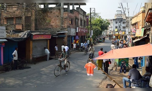
3 / 8Red Road – Kolkata’s British-era boulevard: Red Road, built in 1820 in Calcutta (now Kolkata), was originally laid out by the British as a wide parade ground and boulevard bisecting the Maidan. Over time, it became a major urban thoroughfare linking Fort William with the southern parts of the city. Even today, it remains a central road in Kolkata’s transport network, hosting events like marathons and civic parades. (Picture: Wikimedia Commons)
 4 / 8
4 / 8Bombay-Agra Road – colonial link to the plains: The Bombay–Agra Road, developed by the British to link the western port of Bombay (now Mumbai) to the northern plains, became part of the larger colonial network, facilitating trade and military movement. Over the decades, this route was assimilated into India’s National Highway network, serving as a vital corridor for passenger and freight traffic across several states. (Picture: Wikimedia Commons)
 5 / 8
5 / 8Calcutta-Agra colonial route still in use: The Calcutta–Agra Road was built under British rule to stitch together eastern and northern India, especially to support the colonial administration and mobility. This historic alignment now forms segments of the Grand Trunk Road and modern highways that remain key to northern India’s transport infrastructure. (Picture: Wikimedia Commons)
 6 / 8
6 / 8Madras–Calcutta Road – east-coast connectivity: The British laid the Madras–Calcutta Road to connect the two major presidencies on India’s east coast, promoting military cohesion and resource movement. Today, much of this route continues to serve as vital state and national highways linking the southern and eastern regions of India. (Picture: Wikimedia Commons)
 7 / 8
7 / 8Himalayan military roads – strategic hill connectors: To maintain control over frontier regions in the north, the British built military roads in the Himalayas, especially in present-day Himachal Pradesh, Uttarakhand and Jammu & Kashmir. Many of these alignments have been upgraded yet still serve as vital links for civilian travel, strategic deployment and tourism in mountainous terrains. (Picture: Wikimedia Commons)
 8 / 8
8 / 8Dhalli Tunnel – Shimla’s British-era gateway: Near Shimla, the Dhalli Tunnel was started in 1850 and completed in 1852 under British supervision to improve Himalayan access and mobility. Today, this historic tunnel remains one of the busiest routes connecting the hill station with the plains, illustrating how colonial engineering continues to support modern transport. (Picture: Wikimedia Commons)